| Hurricane Katrina's Winds and Waves |
| | | | | | | |
| A U.S. Government and Insurance Industry Hoax Re-victimizing the Gulf Coast |
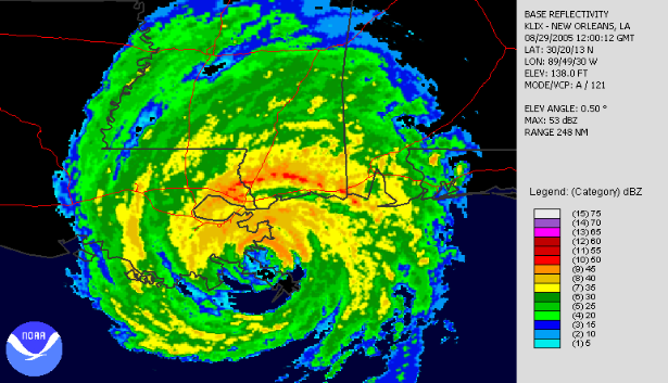
II. 5AM CDT-The inner eyewall is not going away. The eyewall replacement
cycle is being aborted by surface friction as Katrina’s surface winds begin to feel
marshes and woodlands in Louisiana and Mississippi.
cycle is being aborted by surface friction as Katrina’s surface winds begin to feel
marshes and woodlands in Louisiana and Mississippi.
| I. 3AM CDT-Two concentric eyes and eyewalls are evident. The inner eyewall is eroding in its southwest quadrant. This is a consequence of an eyewall replacement cycle in which a new outer eyewall replaces the old eyewall, causing the hurricane wind field to expand. |
IV. 8 AM CDT-Katrina’s maximum wind bands are now demolishing buildings
along the Mississippi coast too. The red color in the northwest and northeast
quadrants signifies strong convective activity. This will cause strong winds aloft to
descend to the surface.
along the Mississippi coast too. The red color in the northwest and northeast
quadrants signifies strong convective activity. This will cause strong winds aloft to
descend to the surface.
V. 10 AM CDT-Katrina’s inner eyewall has come ashore. Convective activity
in the north and east quadrants remains strong. Most of the Hancock County coast
is in Katrina’s eye.
in the north and east quadrants remains strong. Most of the Hancock County coast
is in Katrina’s eye.
III. 7 AM CDT-Katrina’s energy has been concentrated in the north quadrants
of both eyewalls. Maximum wind bands in these eyewalls are now demolishing
buildings along the Louisiana coast.
of both eyewalls. Maximum wind bands in these eyewalls are now demolishing
buildings along the Louisiana coast.
The remarkable radar images shown above were taken by the National
Oceanic and Atmospheric Administration (NOAA), National Weather Service
Offices, New Orleans (Slidell, Louisiana) (KLIX) and Mobile, Alabama
(MOB) as Hurricane Katrina moved to landfall in Mississippi at 9:45 AM
CDT August 29, 2005. Near-surface wind velocities were also derived from
NWSO Slidell NEXRAD Doppler radar located only 16 miles from Katrina's
Mississippi landfall. This report would not have been possible without this
incredibly valuable data observed at great risk. NWSO Slidell was forced to
evacuate at 9 AM.
Hurricane Katrina blasted Mississippi with the destructive power of two
back-to-back hurricanes. Two concentric eyewalls with two maximum wind
bands came ashore after fourteen hours of increasingly violent Tropical
Cyclone and Hurricane force easterly winds. Outer eyewall maximum
winds demolished shoreline communities from Waveland to Pascagoula. Inner
eyewall maximum winds completed the devastation before storm tide
covered the remains. The two eyewalls are evident in the following NEXRAD
Doppler radar images:
